
Thank you for supporting this site ❤️
Make a donation
Make a donation
Hertsmere topographic map
Click on the map to display elevation.
Thank you for supporting this site ❤️
Make a donation
Make a donation
About this map
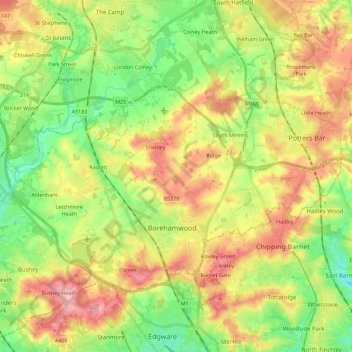
Name: Hertsmere topographic map, elevation, terrain.
Location: Hertsmere, Hertfordshire, England, United Kingdom (51.62351 -0.38693 51.73814 -0.16314)
Average elevation: 95 m
Minimum elevation: 43 m
Maximum elevation: 158 m
Thank you for supporting this site ❤️
Make a donation
Make a donation
Other topographic maps
Click on a map to view its topography, its elevation and its terrain.
Thank you for supporting this site ❤️
Make a donation
Make a donation
Bushey Heath
United Kingdom > England > Hertfordshire > Hertsmere > Bushey Heath
Average elevation: 110 m
Thank you for supporting this site ❤️
Make a donation
Make a donation
Bishops Stortford Elsan Point
United Kingdom > England > Hertfordshire > East Hertfordshire
Average elevation: 78 m