
Tann topographic map
Interactive map
Click on the map to display elevation.
About this map
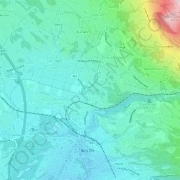
Name: Tann topographic map, elevation, terrain.
Location: Tann, Dürnten, Bezirk Hinwil, Zürich, 8632, Schweiz (47.25138 8.83359 47.29138 8.87359)
Average elevation: 555 m
Minimum elevation: 458 m
Maximum elevation: 971 m
Other topographic maps
Click on a map to view its topography, its elevation and its terrain.
Oberdürnten
Schweiz > Zürich > Bezirk Hinwil
Oberdürnten, Dürnten, Bezirk Hinwil, Zürich, 8635, Schweiz
Average elevation: 616 m
Wetzikon
Schweiz > Zürich > Bezirk Hinwil
Wetzikon, Bezirk Hinwil, Zürich, Schweiz
Average elevation: 563 m
Seegräben
Schweiz > Zürich > Bezirk Hinwil
Seegräben, Bezirk Hinwil, Zürich, 8607, Schweiz
Average elevation: 545 m
Hadlikon
Schweiz > Zürich > Bezirk Hinwil > Hadlikon
Hadlikon, Hinwil, Bezirk Hinwil, Zürich, 8635, Schweiz
Average elevation: 636 m
Bachtel
Schweiz > Zürich > Bezirk Hinwil > Hinwil
Bachtel, Hinwil, Bezirk Hinwil, Zürich, 8342, Schweiz
Average elevation: 868 m
Fischenthal
Schweiz > Zürich > Bezirk Hinwil > Fischenthal
Fischenthal, Bezirk Hinwil, Zürich, Schweiz
Average elevation: 863 m
Hinwil
Schweiz > Zürich > Bezirk Hinwil > Hinwil
Hinwil, Bezirk Hinwil, Zürich, Schweiz
Average elevation: 652 m