
Hinwil topographic map
Interactive map
Click on the map to display elevation.
About this map
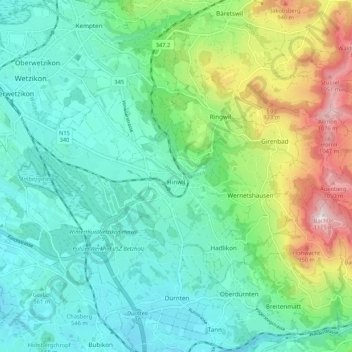
Name: Hinwil topographic map, elevation, terrain.
Location: Hinwil, Bezirk Hinwil, Zürich, Schweiz (47.27875 8.80377 47.32668 8.90979)
Average elevation: 652 m
Minimum elevation: 490 m
Maximum elevation: 1,112 m
Ein beliebtes Ausflugsziel ist der 1115 Meter hohe Hausberg von Hinwil, der Bachtel. Vom 60 Meter hohen Bachtelturm (Aussichtsplattform in 30 Meter Höhe) hat man einen Ausblick über das Zürcher Oberland bis in die Alpen.
Other topographic maps
Click on a map to view its topography, its elevation and its terrain.
Bachtel
Schweiz > Zürich > Bezirk Hinwil > Hinwil
Bachtel, Hinwil, Bezirk Hinwil, Zürich, 8342, Schweiz
Average elevation: 868 m