
Thank you for supporting this site ❤️
Make a donation
Make a donation
Autauga County topographic map
Click on the map to display elevation.
Thank you for supporting this site ❤️
Make a donation
Make a donation
About this map
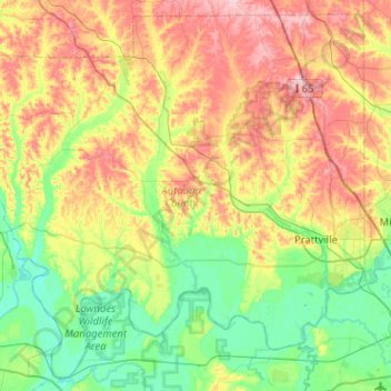
Name: Autauga County topographic map, elevation, terrain.
Location: Autauga County, Alabama, United States (32.30756 -86.92113 32.70808 -86.41110)
Average elevation: 99 m
Minimum elevation: 28 m
Maximum elevation: 220 m
Thank you for supporting this site ❤️
Make a donation
Make a donation
Other topographic maps
Click on a map to view its topography, its elevation and its terrain.
Thank you for supporting this site ❤️
Make a donation
Make a donation
Thank you for supporting this site ❤️
Make a donation
Make a donation