
Make a donation
Baden topographic map
Click on the map to display elevation.
Make a donation
About this map
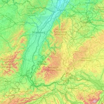
Name: Baden topographic map, elevation, terrain.
Location: Baden, Baden-Württemberg, Germany (47.19284 7.13903 49.19284 9.13903)
Average elevation: 478 m
Minimum elevation: 94 m
Maximum elevation: 2,371 m
Make a donation
Other topographic maps
Click on a map to view its topography, its elevation and its terrain.
Unterreichenbach
Germany > Baden-Württemberg > Landkreis Calw
Unterreichenbach is in the Nagold River Valley between Calw and Pforzheim, at an altitude of between 292 und 633 metres.
Average elevation: 493 m
Make a donation
Backnang
Germany > Baden-Württemberg > Rems-Murr-Kreis
Before 1930 the title for this position was Stadtschultheiß. In 1930 the title became Bürgermeister (Mayor), and in 1956 with the elevation of Backnang to a "large district town," the title was changed to Oberbürgermeister (Lord Mayor).
Average elevation: 302 m
Make a donation
Black Forest
Its highest peak is the Feldberg with an elevation of 1,493 metres (4,898 ft) above sea level. Roughly oblong in shape, with a length of 160 kilometres (100 miles) and breadth of up to 50 km (30 mi), it has an area of about 6,009 km2 (2,320 sq mi).
Average elevation: 469 m
Make a donation