
Thank you for supporting this site ❤️
Make a donation
Make a donation
Unterreichenbach topographic map
Click on the map to display elevation.
Thank you for supporting this site ❤️
Make a donation
Make a donation
Unterreichenbach
Unterreichenbach is in the Nagold River Valley between Calw and Pforzheim, at an altitude of between 292 und 633 metres.
Thank you for supporting this site ❤️
Make a donation
Make a donation
About this map
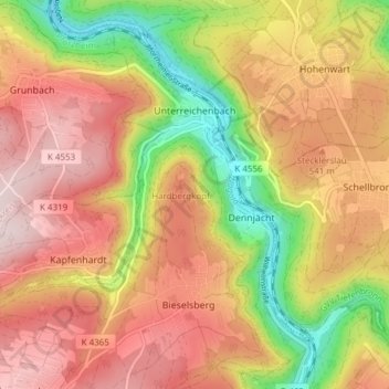
Name: Unterreichenbach topographic map, elevation, terrain.
Average elevation: 493 m
Minimum elevation: 289 m
Maximum elevation: 651 m
Thank you for supporting this site ❤️
Make a donation
Make a donation