
Saint Paul topographic map
Interactive map
Click on the map to display elevation.
About this map
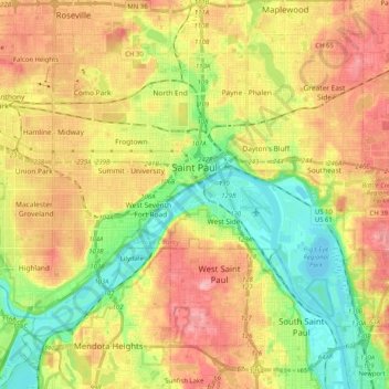
Name: Saint Paul topographic map, elevation, terrain.
Location: Saint Paul, Ramsey County, Minnesota, United States (44.88727 -93.20781 44.99202 -93.00431)
Average elevation: 268 m
Minimum elevation: 207 m
Maximum elevation: 334 m
The year 1858 saw more than 1,000 steamboats service Saint Paul, making it a gateway for settlers to the Minnesota frontier or Dakota Territory. Geography was a primary reason the city became a transportation hub. The location was the last good point to land riverboats coming upriver due to the river valley's topography. For a time, Saint Paul was called "The Last City of the East." Fort Snelling was important to St. Paul from the start. Direct access from St. Paul did not happen until the 7th bridge was built in 1880. Before that, there was a cable ferry crossing dating to at latest the 1840s. Once streetcars appeared, a new bridge to St. Paul was built in 1904. Until the town built its first jail the fort's brig served St. Paul. Industrialist James J. Hill founded his railroad empire in St. Paul. The Great Northern Railway and the Northern Pacific Railway were both headquartered in St. Paul until they merged with the Burlington Northern. Today they are part of the BNSF Railway.
Other topographic maps
Click on a map to view its topography, its elevation and its terrain.
North St. Paul
United States > Minnesota > Ramsey County
North St. Paul, Ramsey County, Minnesota, United States
Average elevation: 302 m
Beaver Lake
United States > Minnesota > Ramsey County > Maplewood
Beaver Lake, Maplewood, Ramsey County, Minnesota, United States
Average elevation: 304 m
Little Canada
United States > Minnesota > Ramsey County
Little Canada, Ramsey County, Minnesota, United States
Average elevation: 277 m
Saint Paul
United States > Minnesota > Ramsey County > Saint Paul
Saint Paul, Ramsey County, Minnesota, 55101, United States
Average elevation: 273 m
North Oaks
United States > Minnesota > Ramsey County
North Oaks, Ramsey County, Minnesota, United States
Average elevation: 280 m
Roseville
United States > Minnesota > Ramsey County
Roseville, Ramsey County, Minnesota, 55113, United States
Average elevation: 284 m
White Bear Township
United States > Minnesota > Ramsey County
White Bear Township, Ramsey County, Minnesota, 55110, United States
Average elevation: 282 m
Southeast
United States > Minnesota > Ramsey County > Saint Paul
Southeast, Saint Paul, Ramsey County, Minnesota, United States
Average elevation: 263 m
Highland Park
United States > Minnesota > Ramsey County > Saint Paul
Highland Park, Highland, Saint Paul, Ramsey County, Minnesota, United States
Average elevation: 255 m
White Bear Lake
United States > Minnesota > Ramsey County
White Bear Lake, Ramsey County, Minnesota, 55110, United States
Average elevation: 289 m
Mounds View
United States > Minnesota > Ramsey County
Mounds View, Ramsey County, Minnesota, United States
Average elevation: 276 m
Summit Hill
United States > Minnesota > Ramsey County > Saint Paul
Summit Hill, Saint Paul, Ramsey County, Minnesota, United States
Average elevation: 267 m
Maplewood
United States > Minnesota > Ramsey County
Maplewood, Ramsey County, Minnesota, United States
Average elevation: 279 m
New Brighton
United States > Minnesota > Ramsey County
New Brighton, Ramsey County, Minnesota, 55112, United States
Average elevation: 282 m
South Saint Anthony Park
United States > Minnesota > Ramsey County > Saint Paul
South Saint Anthony Park, Saint Anthony Park, Saint Paul, Ramsey County, Minnesota, United States
Average elevation: 270 m
Vadnais Heights
United States > Minnesota > Ramsey County
Vadnais Heights, Ramsey County, Minnesota, 55127, United States
Average elevation: 279 m
White Bear Township
United States > Minnesota > Ramsey County
White Bear Township, Ramsey County, Minnesota, United States
Average elevation: 283 m
Shoreview
United States > Minnesota > Ramsey County
Shoreview, Ramsey County, Minnesota, 55126, United States
Average elevation: 279 m