
Make a donation
Navarre topographic map
Click on the map to display elevation.
Make a donation
Navarre
Despite its relatively small size, Navarre features stark contrasts in geography, from the Pyrenees mountain range that dominates the territory to the plains of the Ebro river valley in the south. The highest point in Navarre is Mesa de los Tres Reyes, with an elevation of 2,428 metres (7,965 feet).
Make a donation
About this map
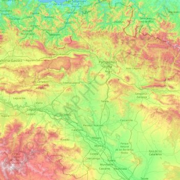
Name: Navarre topographic map, elevation, terrain.
Location: Navarre, Spain (41.90989 -2.49994 43.31495 -0.72334)
Average elevation: 629 m
Minimum elevation: -1 m
Maximum elevation: 2,144 m
Make a donation
Other topographic maps
Click on a map to view its topography, its elevation and its terrain.
Make a donation
Make a donation
Make a donation
Puente de Domingo Flórez
Spain > Castile and León > El Bierzo > Puente de Domingo Flórez
Average elevation: 527 m
Make a donation
Foronda
Spain > Autonomous Community of the Basque Country > Gasteizko kuadrilla/Cuadrilla de Vitoria > Vitoria-Gasteiz
Average elevation: 525 m
Make a donation
Castillo de Peñiscola
Spain > Valencian Community > Castelló / Castellón > Peníscola / Peñíscola
The castle is situated on a crag overlooking the Mediterranean Sea, at an altitude of 64 metres (210 ft) above mean sea level.
Average elevation: 5 m
Make a donation
Make a donation
Make a donation
Make a donation
Madrid
Spain > Community of Madrid > Área metropolitana de Madrid y Corredor del Henares > Madrid
Average elevation: 650 m
Vigo
Vigo has a warm-summer Mediterranean climate "Csb" according to the Köppen climate classification. Although Vigo is the rainiest city in Galicia, nowadays, with its noticeable drying trend in the summer, Vigo's climate is more similar to the variant of the oceanic climate commonly seen in the Pacific…
Average elevation: 121 m
Make a donation
Murcia
Spain > Region of Murcia > Área Metropolitana de Murcia > Murcia
Murcia is located near the center of a low-lying fertile plain known as the huerta (orchard or vineyard) of Murcia. The Segura River and its right-hand tributary, the Guadalentín, run through the area. The city has an elevation of 43 metres (141 ft) above sea level and its municipality covers approximately…
Average elevation: 169 m
Make a donation
Biañez
Spain > Autonomous Community of the Basque Country > Karrantza Harana / Valle de Carranza > Biañez
Average elevation: 232 m
Pollença
Spain > Balearic Islands > Serra de Tramuntana > Pollença > Pollença
Average elevation: 156 m
Make a donation
Make a donation