
Sillenbuch topographic map
Interactive map
Click on the map to display elevation.
About this map
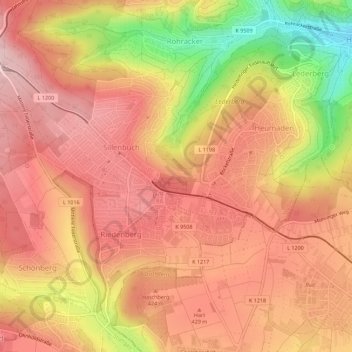
Name: Sillenbuch topographic map, elevation, terrain.
Location: Sillenbuch, Estugarda, Baden-Württemberg, 70619, Alemanha (48.72639 9.19108 48.75774 9.24702)
Average elevation: 397 m
Minimum elevation: 240 m
Maximum elevation: 478 m
Other topographic maps
Click on a map to view its topography, its elevation and its terrain.
Estugarda
Alemanha > Baden-Württemberg > Estugarda
Estugarda, Stuttgart, Regierungsbezirk Stuttgart, Baden-Württemberg, 70173, Alemanha
Average elevation: 353 m