
Maspalomas topographic map
Interactive map
Click on the map to display elevation.
About this map
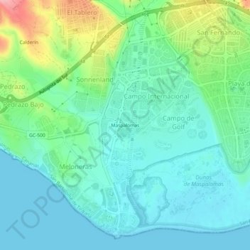
Name: Maspalomas topographic map, elevation, terrain.
Average elevation: 34 m
Minimum elevation: 0 m
Maximum elevation: 140 m
Trotzdem hebt sich Playa del Inglés von vergleichbaren spanischen Massentourismuszielen wie beispielsweise Benidorm oder Torremolinos immer noch positiv durch eine deutlich geringere Bebauungsdichte und eine geringere Bauhöhe ab.
Other topographic maps
Click on a map to view its topography, its elevation and its terrain.
El Pajar
Spanien > San Bartolomé de Tirajana
El Pajar, San Bartolomé de Tirajana, Las Palmas, Kanarische Inseln, 35120, Spanien
Average elevation: 30 m