
Bener Meriah topographic map
Interactive map
Click on the map to display elevation.
About this map
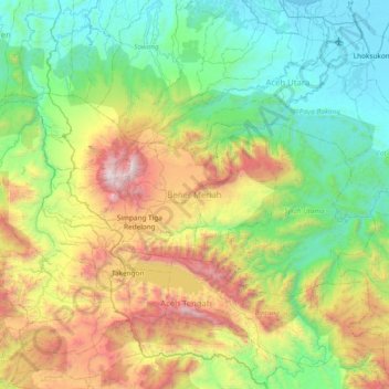
Name: Bener Meriah topographic map, elevation, terrain.
Location: Bener Meriah, Aceh, Sumatra, Indonésie (4.57760 96.57593 4.97020 97.32872)
Average elevation: 795 m
Minimum elevation: -1 m
Maximum elevation: 2,846 m
Other topographic maps
Click on a map to view its topography, its elevation and its terrain.
Gunung Sumbing
Gunung Sumbing, Serbajadi, Aceh Timur, Aceh, Indonésie
Average elevation: 1,218 m
Geureudong
Geureudong, Gajah Putih, Bener Meriah, Aceh, Indonésie
Average elevation: 2,558 m