
Pedu Lake topographic map
Interactive map
Click on the map to display elevation.
About this map
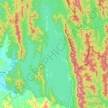
Name: Pedu Lake topographic map, elevation, terrain.
Location: Pedu Lake, Pdg Terap, Kedah, Malaysia (6.17348 100.76475 6.33275 100.84527)
Average elevation: 203 m
Minimum elevation: 36 m
Maximum elevation: 550 m
Other topographic maps
Click on a map to view its topography, its elevation and its terrain.
Sungai Petani
Malaysia > Kedah > Sungai Petani
Sungai Petani, Kuala Muda, Kedah, 08000, Malaysia
Average elevation: 45 m
Kuala Nerang
Kuala Nerang, Padang Terap, Kedah, 06300, Malaysia
Average elevation: 32 m