
Thank you for supporting this site ❤️
Make a donation
Make a donation
Kuah topographic map
Click on the map to display elevation.
Thank you for supporting this site ❤️
Make a donation
Make a donation
About this map
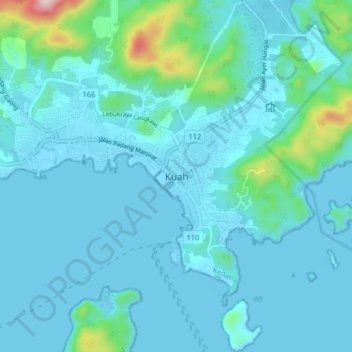
Name: Kuah topographic map, elevation, terrain.
Location: Kuah, Langkawi, Kedah, Malaysia (6.28053 99.81033 6.36053 99.89033)
Average elevation: 61 m
Minimum elevation: -2 m
Maximum elevation: 562 m
Thank you for supporting this site ❤️
Make a donation
Make a donation
Other topographic maps
Click on a map to view its topography, its elevation and its terrain.