
Heimbach topographic map
Interactive map
Click on the map to display elevation.
About this map
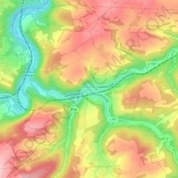
Name: Heimbach topographic map, elevation, terrain.
Average elevation: 412 m
Minimum elevation: 305 m
Maximum elevation: 499 m
Other topographic maps
Click on a map to view its topography, its elevation and its terrain.
Baumholder
Germany > Rhineland-Palatinate > Landkreis Birkenfeld
Baumholder, Landkreis Birkenfeld, Rhineland-Palatinate, 55774, Germany
Average elevation: 451 m
Birkenfeld
Germany > Rhineland-Palatinate > Landkreis Birkenfeld > Birkenfeld
Birkenfeld, Landkreis Birkenfeld, Rhineland-Palatinate, Germany
Average elevation: 425 m