
Make a donation
Muli Tibetan Autonomous County topographic map
Click on the map to display elevation.
Make a donation
Muli Tibetan Autonomous County
Since 1987, Muli Monastery has been partly restored and now has about eighty young monks in residence. It is near a modern small town called Wachang, located high up on the western edge of the Litang River Valley at about 3000 metres altitude. The other monasteries are Kulu (now known as Kangwu), which has been partially rebuilt, and Waerdje (now Wa’erzhai) which is still in ruins.
Make a donation
About this map
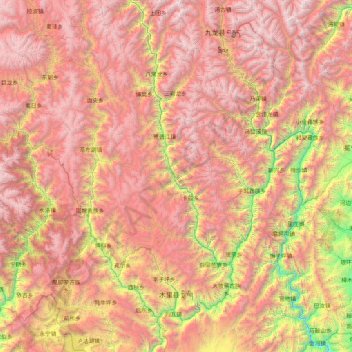
Name: Muli Tibetan Autonomous County topographic map, elevation, terrain.
Average elevation: 3,390 m
Minimum elevation: 1,265 m
Maximum elevation: 5,464 m
Make a donation
Other topographic maps
Click on a map to view its topography, its elevation and its terrain.
Large High Altitude Air Shower Observatory
China > Sichuan > Daocheng County
The Large High Altitude Air Shower Observatory (LHAASO) is a gamma-ray and cosmic-ray observatory in Daocheng, in the Garzê Tibetan Autonomous Prefecture in Sichuan, China. It is designed to observe air showers triggered by gamma rays and cosmic rays. The observatory is at an altitude of 4,410 metres (14,470…
Average elevation: 4,421 m
Make a donation
Litang
China > Sichuan > Litang County
Litang County is located in the west of Sichuan, the southwest of Garze Tibetan Autonomous Prefecture, between the Jinsha River and the Yalong River on the southeastern edge of the Qinghai-Tibet Plateau. The Shaluli Mountains runs from north to south. The terrain is dominated by hill-shaped plateaus and…
Average elevation: 4,305 m