
Menifee topographic map
Click on the map to display elevation.
Menifee
The city is centrally located in Southern California in the Menifee Valley. It is almost 15 miles (24 km) north of Temecula and just north of Murrieta. Menifee is roughly 46 square miles (100 km2) in size and has an elevation of 1,424 feet (434 m). The incorporated City of Menifee includes the communities of Sun City, Quail Valley, and Romoland.
About this map
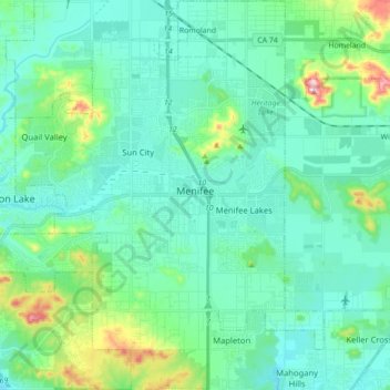
Name: Menifee topographic map, elevation, terrain.
Location: Menifee, Riverside County, California, United States (33.61164 -117.25814 33.75775 -117.11884)
Average elevation: 474 m
Minimum elevation: 407 m
Maximum elevation: 773 m
Other topographic maps
Click on a map to view its topography, its elevation and its terrain.
Mountain Center
United States > California > Riverside County
It lies centered on the junction of State Route 74 and State Route 243 in the southern division of San Bernardino National Forest. Mountain Center lies just north of Lake Hemet, midway between Hemet and Palm Desert, just south of the town of Idyllwild, and it is southeast of the city of Riverside, the county…
Average elevation: 1,476 m