
Yuseong-gu topographic map
Interactive map
Click on the map to display elevation.
About this map
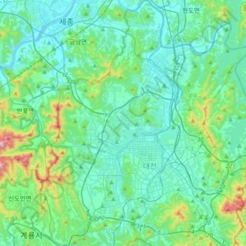
Name: Yuseong-gu topographic map, elevation, terrain.
Location: Yuseong-gu, Daejeon, South Korea (36.26448 127.24632 36.49988 127.41872)
Average elevation: 126 m
Minimum elevation: 8 m
Maximum elevation: 722 m
Other topographic maps
Click on a map to view its topography, its elevation and its terrain.
Seattle Park
Seattle Park, Dunsan-dong, Dunsan 1(il)-dong, Seo-gu, Daejeon, South Korea
Average elevation: 51 m
Sinseong-dong
Sinseong-dong, Yuseong-gu, Daejeon, South Korea
Average elevation: 111 m
Jayang-dong
South Korea > Daejeon > Jayang-dong
Jayang-dong, Dong-gu, Daejeon, South Korea
Average elevation: 96 m
Hyo-dong
South Korea > Daejeon > Hyo-dong
Hyo-dong, Dong-gu, Daejeon, South Korea
Average elevation: 109 m