
Gilbert Hill topographic map
Interactive map
Click on the map to display elevation.
About this map
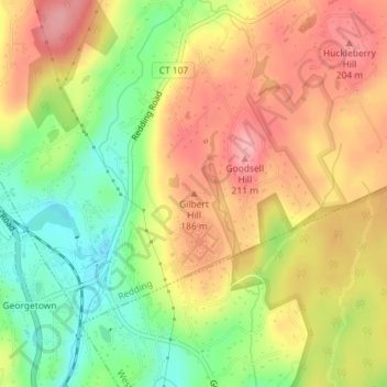
Name: Gilbert Hill topographic map, elevation, terrain.
Location: Gilbert Hill, Fairfield, Connecticut, 06829, USA (41.26338 -73.41962 41.26348 -73.41952)
Average elevation: 152 m
Minimum elevation: 88 m
Maximum elevation: 206 m
Other topographic maps
Click on a map to view its topography, its elevation and its terrain.
Terramuggus
USA > Connecticut > Terramuggus
Terramuggus, Keirstead Circle, Terramuggus, Hartford County, Connecticut, 06447, USA
Average elevation: 150 m
The Plans
USA > Connecticut > Norwalk
The Plans, Norwalk, Fairfield, Connecticut, USA
Average elevation: 0 m
Major Island
Major Island, New London County, Connecticut, USA
Average elevation: 16 m