
Bukit Raja topographic map
Interactive map
Click on the map to display elevation.
About this map
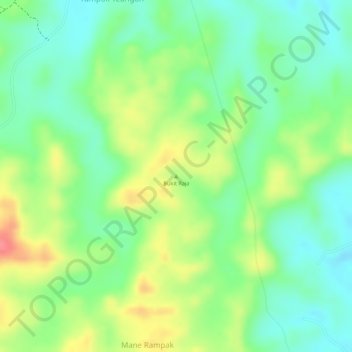
Name: Bukit Raja topographic map, elevation, terrain.
Location: Bukit Raja, Julok, Aceh Timur, Aceh, Indonesia (5.00625 97.59405 5.00635 97.59415)
Average elevation: 50 m
Minimum elevation: 16 m
Maximum elevation: 97 m
Other topographic maps
Click on a map to view its topography, its elevation and its terrain.
Bitai
Indonesia > Aceh > Aceh Besar > Bitai
Bitai, Darul Imarah, Aceh Besar, Aceh, 23238, Indonesia
Average elevation: 24 m
Paya Lumpat
Indonesia > Aceh > Paya Lumpat
Paya Lumpat, Samatiga, Aceh Barat, Aceh, 23651, Indonesia
Average elevation: 6 m
Mount Leuser
Mount Leuser, Kuta Panjang, Gayo Lues, Aceh, Indonesia
Average elevation: 2,556 m
Gunung Mugajah
Gunung Mugajah, Serbajadi, Aceh Timur, Aceh, Indonesia
Average elevation: 2,189 m
Gunung Bandahara
Gunung Bandahara, Putri Betung, Gayo Lues, Aceh, Indonesia
Average elevation: 2,634 m