
Roßleben-Wiehe topographic map
Interactive map
Click on the map to display elevation.
About this map
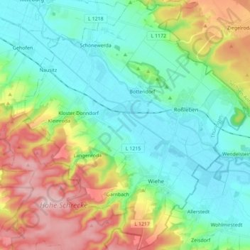
Name: Roßleben-Wiehe topographic map, elevation, terrain.
Location: Roßleben-Wiehe, Kyffhäuserkreis, Thüringen, 06571, Deutschland (51.23657 11.30350 51.34451 11.47575)
Average elevation: 195 m
Minimum elevation: 112 m
Maximum elevation: 384 m
Other topographic maps
Click on a map to view its topography, its elevation and its terrain.
Der Queckborn
Deutschland > Thüringen > Roßleben-Wiehe
Der Queckborn, Wiehe, Roßleben-Wiehe, Kyffhäuserkreis, Thüringen, Deutschland
Average elevation: 274 m