
Riedern topographic map
Interactive map
Click on the map to display elevation.
About this map
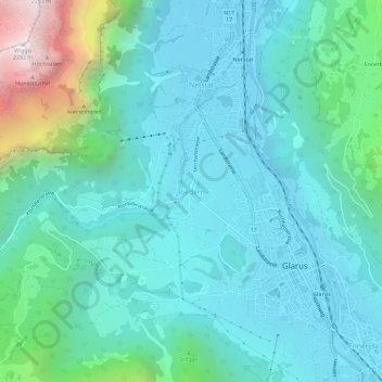
Name: Riedern topographic map, elevation, terrain.
Location: Riedern, Glarus, 8750, Schweiz (47.02995 9.03152 47.06995 9.07152)
Average elevation: 780 m
Minimum elevation: 451 m
Maximum elevation: 2,266 m
Other topographic maps
Click on a map to view its topography, its elevation and its terrain.
Klöntalersee
Klöntalersee, Seestrasse, Plätz, Glarus, 6667, Schweiz
Average elevation: 1,432 m
Schwander Grat
Schwander Grat, Klöntalerstrasse, Glarus, 6667, Schweiz
Average elevation: 2,267 m
Glärnischfirn
Glärnischfirn, Seestrasse, Plätz, Glarus, 6667, Schweiz
Average elevation: 2,383 m