
Bächistock topographic map
Interactive map
Click on the map to display elevation.
About this map
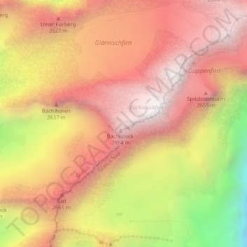
Name: Bächistock topographic map, elevation, terrain.
Location: Bächistock, Glarus, Schweiz (46.99356 8.98960 46.99366 8.98970)
Average elevation: 2,394 m
Minimum elevation: 1,526 m
Maximum elevation: 2,900 m
Other topographic maps
Click on a map to view its topography, its elevation and its terrain.
Klöntalersee
Klöntalersee, Seestrasse, Plätz, Glarus, 6667, Schweiz
Average elevation: 1,432 m
Schwander Grat
Schwander Grat, Klöntalerstrasse, Glarus, 6667, Schweiz
Average elevation: 2,267 m
Glärnischfirn
Glärnischfirn, Seestrasse, Plätz, Glarus, 6667, Schweiz
Average elevation: 2,383 m