
Lake Waitaki topographic map
Interactive map
Click on the map to display elevation.
About this map
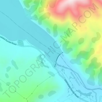
Name: Lake Waitaki topographic map, elevation, terrain.
Location: Lake Waitaki, Waitaki District, Canterbury, Nueva Zelanda (-44.69695 170.41422 -44.67695 170.43422)
Average elevation: 349 m
Minimum elevation: 205 m
Maximum elevation: 801 m
Other topographic maps
Click on a map to view its topography, its elevation and its terrain.
Lake Hood
Nueva Zelanda > Canterbury > Ashburton District > Lake Hood
Lake Hood, Ashburton District, Canterbury, Nueva Zelanda
Average elevation: 62 m
Pukaki High Dam
Pukaki High Dam, Mackenzie District, Canterbury, Nueva Zelanda
Average elevation: 534 m
Lake Coleridge
Nueva Zelanda > Canterbury > Lake Coleridge
Lake Coleridge, Selwyn District, Canterbury, Nueva Zelanda
Average elevation: 422 m
Lake Pūkaki
Lake Pūkaki, Hayman Road, Mackenzie District, Canterbury, Nueva Zelanda
Average elevation: 886 m
Lake Benmore
Lake Benmore, Falston Road, Waitaki District, Canterbury, Nueva Zelanda
Average elevation: 746 m
Isla Sur
Isla Sur, Ashburton District, Canterbury, Nueva Zelanda
Average elevation: 201 m