
Pottsville topographic map
Interactive map
Click on the map to display elevation.
About this map
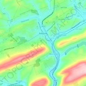
Name: Pottsville topographic map, elevation, terrain.
Average elevation: 262 m
Minimum elevation: 174 m
Maximum elevation: 426 m
Pottsville experiences a humid subtropical climate (Cfa) according to the Köppen climate classification system if the 26.6 °F (−3.0 °C) isotherm is used, or a humid continental climate (Dfa) if the 32 °F (0 °C) isotherm is used. The record high was 104 °F (40 °C) in 2011, and the record low was −19 °F (−28 °C) in 1994. Average monthly temperatures range from 27.3 °F in January to 72.3 °F in July. [2] The hardiness zone is 6b or 7a depending upon elevation. [3]
Other topographic maps
Click on a map to view its topography, its elevation and its terrain.
Tamaqua
United States > Pennsylvania > Schuylkill County
Tamaqua, Schuylkill County, Pennsylvania, 18252, United States
Average elevation: 352 m
Frackville
United States > Pennsylvania > Schuylkill County
Frackville, Schuylkill County, Pennsylvania, 17931, United States
Average elevation: 446 m
Schuylkill Haven
United States > Pennsylvania > Schuylkill County
Schuylkill Haven, Schuylkill County, Pennsylvania, 17972, United States
Average elevation: 184 m