
Schuylkill Haven topographic map
Interactive map
Click on the map to display elevation.
About this map
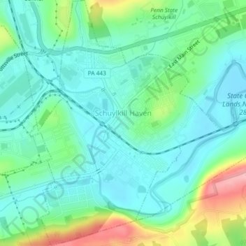
Name: Schuylkill Haven topographic map, elevation, terrain.
Average elevation: 184 m
Minimum elevation: 147 m
Maximum elevation: 287 m
Schuylkill Haven was developed around the Schuylkill River, which flows through the town entering northwest of Island Park near Fritz Reed Avenue, and exits at the southeastern border. The river's elevation in the borough is approximately 490 feet (150 m) above sea level. Farther from the river, the borough extends up numerous hills, reaching its highest elevation at approximately 700 feet (210 m) above sea level near the top of Avenue C.
Other topographic maps
Click on a map to view its topography, its elevation and its terrain.
Tamaqua
United States > Pennsylvania > Schuylkill County
Tamaqua, Schuylkill County, Pennsylvania, 18252, United States
Average elevation: 352 m
Frackville
United States > Pennsylvania > Schuylkill County
Frackville, Schuylkill County, Pennsylvania, 17931, United States
Average elevation: 446 m
Pottsville
United States > Pennsylvania > Schuylkill County
Pottsville, Schuylkill County, Pennsylvania, 17901, United States
Average elevation: 262 m