
Cappenberg topographic map
Interactive map
Click on the map to display elevation.
About this map
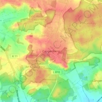
Name: Cappenberg topographic map, elevation, terrain.
Average elevation: 89 m
Minimum elevation: 56 m
Maximum elevation: 114 m
Other topographic maps
Click on a map to view its topography, its elevation and its terrain.
Ternscher See
Deutschland > Nordrhein-Westfalen > Kreis Unna > Selm
Ternscher See, Selm, Kreis Unna, Nordrhein-Westfalen, 59379, Deutschland
Average elevation: 52 m
Netteberge
Deutschland > Nordrhein-Westfalen > Kreis Unna > Selm > Netteberge
Netteberge, Selm, Kreis Unna, Nordrhein-Westfalen, 59379, Deutschland
Average elevation: 83 m