
Make a donation
Ternscher See topographic map
Click on the map to display elevation.
Make a donation
About this map
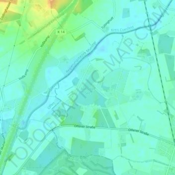
Name: Ternscher See topographic map, elevation, terrain.
Average elevation: 52 m
Minimum elevation: 45 m
Maximum elevation: 73 m
Make a donation
Other topographic maps
Click on a map to view its topography, its elevation and its terrain.
Cappenberg
Deutschland > Nordrhein-Westfalen > Kreis Unna > Selm
Auf einem Höhenrücken liegt das Schloss Cappenberg. Das ehemals bedeutende Prämonstratenserkloster wurde nach der Säkularisation zum Altersruhesitz des bekannten preußischen Verwaltungsreformers Freiherr Karl vom und zum Stein. Seinen Nachkommen, der gräflichen Familie von Kanitz, gehört es noch heute.
Average elevation: 89 m
Make a donation
Cappenberg
Deutschland > Nordrhein-Westfalen > Kreis Unna > Selm
Auf einem Höhenrücken liegt das Schloss Cappenberg. Das ehemals bedeutende Prämonstratenserkloster wurde nach der Säkularisation zum Altersruhesitz des bekannten preußischen Verwaltungsreformers Freiherr Karl vom und zum Stein. Seinen Nachkommen, der gräflichen Familie von Kanitz, gehört es noch heute.
Average elevation: 89 m