
Muscat topographic map
Interactive map
Click on the map to display elevation.
About this map
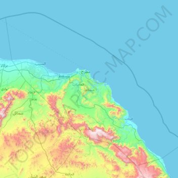
Name: Muscat topographic map, elevation, terrain.
Location: Muscat, Oman (22.89925 57.89352 24.06818 59.37531)
Average elevation: 266 m
Minimum elevation: -1 m
Maximum elevation: 1,964 m
Other topographic maps
Click on a map to view its topography, its elevation and its terrain.
Marina Bander Al Rowdha
Marina Bander Al Rowdha, Al Saidiya Street, Muscat, 940, Oman
Average elevation: 32 m
Mintaqat al Wadi al Kabir as Sinaiyah
Oman > Muscat > Muscat > Mintaqat al Wadi al Kabir as Sinaiyah
Mintaqat al Wadi al Kabir as Sinaiyah, Muscat, 284/117, Oman
Average elevation: 117 m