
Sengscheid topographic map
Interactive map
Click on the map to display elevation.
About this map
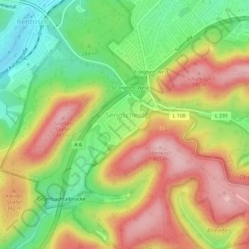
Name: Sengscheid topographic map, elevation, terrain.
Location: Sengscheid, St. Ingbert, Saarpfalz-Kreis, Saarland, Deutschland (49.24563 7.07944 49.26383 7.10821)
Average elevation: 303 m
Minimum elevation: 206 m
Maximum elevation: 401 m
Other topographic maps
Click on a map to view its topography, its elevation and its terrain.
St. Ingbert-Mitte
Deutschland > Saarland > St. Ingbert
St. Ingbert-Mitte, St. Ingbert, Saarpfalz-Kreis, Saarland, 66386, Deutschland
Average elevation: 292 m