
Cheongwon-gu topographic map
Interactive map
Click on the map to display elevation.
About this map
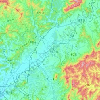
Name: Cheongwon-gu topographic map, elevation, terrain.
Location: Cheongwon-gu, Cheongju-si, North Chungcheong, South Korea (36.64476 127.31809 36.78026 127.61874)
Average elevation: 135 m
Minimum elevation: 20 m
Maximum elevation: 577 m
Other topographic maps
Click on a map to view its topography, its elevation and its terrain.
Heungdeok-gu
Heungdeok-gu, Cheongju-si, North Chungcheong, South Korea
Average elevation: 74 m
Sangdang-gu
Sangdang-gu, Cheongju-si, North Chungcheong, South Korea
Average elevation: 165 m