
Sangdang-gu topographic map
Interactive map
Click on the map to display elevation.
About this map
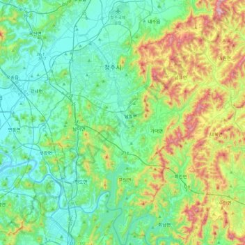
Name: Sangdang-gu topographic map, elevation, terrain.
Location: Sangdang-gu, Cheongju-si, North Chungcheong, South Korea (36.40728 127.44517 36.72999 127.77000)
Average elevation: 165 m
Minimum elevation: 12 m
Maximum elevation: 623 m
Other topographic maps
Click on a map to view its topography, its elevation and its terrain.
Heungdeok-gu
Heungdeok-gu, Cheongju-si, North Chungcheong, South Korea
Average elevation: 74 m
Cheongwon-gu
Cheongwon-gu, Cheongju-si, North Chungcheong, South Korea
Average elevation: 135 m