
Montalcino topographic map
Interactive map
Click on the map to display elevation.
About this map
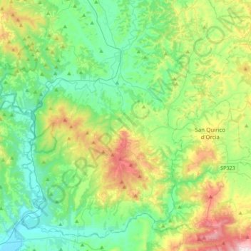
Name: Montalcino topographic map, elevation, terrain.
Location: Montalcino, Siena, Tuscany, Italy (42.95730 11.34984 43.17755 11.68697)
Average elevation: 278 m
Minimum elevation: 62 m
Maximum elevation: 837 m
Other topographic maps
Click on a map to view its topography, its elevation and its terrain.
Radda in Chianti
Radda in Chianti, Siena, Tuscany, 53017, Italy
Average elevation: 484 m
Valle Saccaia
Italy > Tuscany > Siena > Cetona
Valle Saccaia, Cetona, Unione dei Comuni Valdichiana Senese, Siena, Tuscany, Italy
Average elevation: 706 m
Santa Chiara
Italy > Tuscany > Siena > San Gimignano
Santa Chiara, San Gimignano, Siena, Tuscany, 53037, Italy
Average elevation: 255 m