
Gruitrode topographic map
Interactive map
Click on the map to display elevation.
About this map
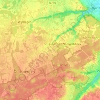
Name: Gruitrode topographic map, elevation, terrain.
Location: Gruitrode, Oudsbergen, Maaseik, Limburg, Flanders, Belgium (51.05489 5.54334 51.11461 5.66607)
Average elevation: 71 m
Minimum elevation: 40 m
Maximum elevation: 87 m
Other topographic maps
Click on a map to view its topography, its elevation and its terrain.
Opglabbeek
Belgium > Limburg > Maaseik > Oudsbergen
Opglabbeek, Oudsbergen, Maaseik, Limburg, Flanders, 3660, Belgium
Average elevation: 79 m