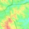
Madison County topographic map
Click on the map to display elevation.
About this map

Name: Madison County topographic map, elevation, terrain.
Location: Madison County, North Carolina, United States (35.67814 -82.96290 36.06592 -82.40861)
Average elevation: 802 m
Minimum elevation: 351 m
Maximum elevation: 1,669 m
Other topographic maps
Click on a map to view its topography, its elevation and its terrain.


Siler City Water Supply Lake Number One Dam
United States > North Carolina > Chatham County
Average elevation: 187 m