
Kechnec topographic map
Interactive map
Click on the map to display elevation.
About this map
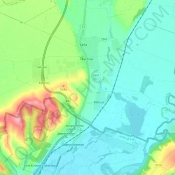
Name: Kechnec topographic map, elevation, terrain.
Average elevation: 188 m
Minimum elevation: 154 m
Maximum elevation: 281 m
The village lies at an altitude of 180 metres and covers an area of 10.211 km2. The municipality is part of the administrative units Košice-okolie District and Košice Region. It has a population of about 1080 people.
Other topographic maps
Click on a map to view its topography, its elevation and its terrain.
Čečejovce
Slovakia > Region of Košice > District of Košice - okolie
Čečejovce, District of Košice - okolie, Region of Košice, Eastern Slovakia, 044 71, Slovakia
Average elevation: 217 m