
Make a donation
Doha topographic map
Click on the map to display elevation.
Make a donation
Doha
Doha is located on the central-east portion of Qatar, bordered by the Persian Gulf on its coast. Its elevation is 10 m (33 ft). Doha is highly urbanized. Land reclamation off the coast has added 400 hectares of land and 30 km of coastline. Half of the 22 km² of surface area which Hamad International Airport was constructed on was reclaimed land. The geology of Doha is primarily composed of weathered unconformity on the top of the Eocene period Dammam Formation, forming dolomitic limestone.
Make a donation
About this map
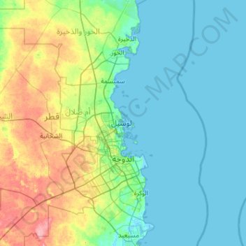
Name: Doha topographic map, elevation, terrain.
Location: Doha, Qatar (25.15054 51.39577 25.68320 52.41712)
Average elevation: 16 m
Minimum elevation: -2 m
Maximum elevation: 79 m
Make a donation
Other topographic maps
Click on a map to view its topography, its elevation and its terrain.
Lusail
Groundwater quality in the area is poor. On the city's border with the Persian Gulf, the groundwater elevation is 1 meter above sea level and flows east-to-west. Salinity levels are highest on the eastern side, at 40 ppt, compared to a low of 18 ppt in the western section; these levels are too high for…
Average elevation: 3 m