
Lusail topographic map
Interactive map
Click on the map to display elevation.
About this map
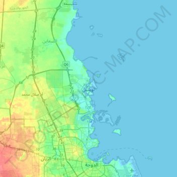
Name: Lusail topographic map, elevation, terrain.
Location: Lusail, Al Daayen, 24685, Qatar (25.38289 51.47972 25.46289 51.55972)
Average elevation: 3 m
Minimum elevation: -3 m
Maximum elevation: 23 m
Groundwater quality in the area is poor. On the city's border with the Persian Gulf, the groundwater elevation is 1 meter above sea level and flows east-to-west. Salinity levels are highest on the eastern side, at 40 ppt, compared to a low of 18 ppt in the western section; these levels are too high for consumption or use in agriculture. Because of the groundwater's high salinity, only salt- and drought-tolerant plants grow in this area. A geographic survey found 25 species of plants within city limits; all of which are found abundantly elsewhere on the peninsula.