
Valentia topographic map
Interactive map
Click on the map to display elevation.
About this map
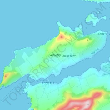
Name: Valentia topographic map, elevation, terrain.
Average elevation: 39 m
Minimum elevation: -1 m
Maximum elevation: 397 m
Eine Ringstraße erschließt die Insel. Während die südliche, die R565, die Verkehre aufnimmt, führt die nördliche, höher gelegene zu den Vorzeitdenkmälern (Menhire, Oghamsteinen und Wedge Tombs). Abzweige zur West- und Nordküste führen zu weiteren Plätzen.
Other topographic maps
Click on a map to view its topography, its elevation and its terrain.
Curraheen
Curraheen, Glanbehy ED, Kenmare Municipal District, County Kerry, Munster, Irland
Average elevation: 124 m
Kenmare Municipal District
Kenmare Municipal District, County Kerry, Munster, Irland
Average elevation: 98 m
An Coimín Theas
An Coimín Theas, Toghroinn ceantair Dún Chaoin, Kenmare Municipal District, County Kerry, Munster, Irland
Average elevation: 248 m
Ross Behy
Ross Behy, Glanbehy ED, Kenmare Municipal District, County Kerry, Munster, V93 H5W9, Irland
Average elevation: 57 m