
San Salvo topographic map
Interactive map
Click on the map to display elevation.
About this map
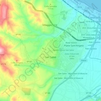
Name: San Salvo topographic map, elevation, terrain.
Location: San Salvo, Chieti, Abruzzen, Italië (42.01440 14.71323 42.08065 14.78389)
Average elevation: 83 m
Minimum elevation: 0 m
Maximum elevation: 286 m
Other topographic maps
Click on a map to view its topography, its elevation and its terrain.
Ripa Teatina
Ripa Teatina, Chieti, Abruzzen, Italië
Average elevation: 132 m