
Chinle topographic map
Interactive map
Click on the map to display elevation.
About this map
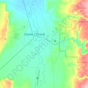
Name: Chinle topographic map, elevation, terrain.
Average elevation: 1,715 m
Minimum elevation: 1,659 m
Maximum elevation: 1,872 m
Chinle liegt westlich unterhalb des maximal 2400 m hohen Defiance Plateau in einer Höhe von 1678 m. Der Ort liegt in der Navajo Nation Reservation und grenzt an das Canyon de Chelly National Monument, eine Canyon-Landschaft mit besonderer geologischer und historischer Bedeutung. Westlich der Stadt verläuft der U.S. Highway 191.
Other topographic maps
Click on a map to view its topography, its elevation and its terrain.
Sawmill
Vereinigte Staaten von Amerika > Arizona > Apache County
Sawmill, Fort Defiance Agency / Tséhootsooí Bił Hahoodzo biyiʼdi, Apache County, Arizona, 86549, Vereinigte Staaten von Amerika
Average elevation: 2,354 m