
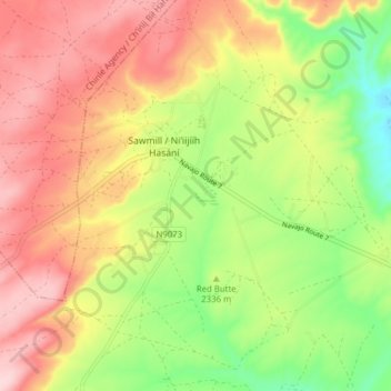
Sawmill topographic map
Interactive map
Click on the map to display elevation.
About this map
Name: Sawmill topographic map, elevation, terrain.
Average elevation: 2,354 m
Minimum elevation: 2,238 m
Maximum elevation: 2,462 m
Sawmill hat eine Fläche von 15 km². Die Bevölkerungsdichte liegt bei 38 Einwohnern je km². Die Stadt liegt in einer Höhe von 1628 m. ü. M.
Other topographic maps
Click on a map to view its topography, its elevation and its terrain.
Chinle
Vereinigte Staaten von Amerika > Arizona > Apache County
Chinle, Chinle Agency / Chʼíńlį́ Bił Hahoodzo biyiʼdi, Apache County, Arizona, 87503, Vereinigte Staaten von Amerika
Average elevation: 1,715 m