
Hòa Bình City topographic map
Interactive map
Click on the map to display elevation.
About this map
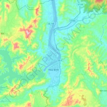
Name: Hòa Bình City topographic map, elevation, terrain.
Location: Hòa Bình City, Hoà Bình province, Vietnam (20.74381 105.26228 21.02427 105.46274)
Average elevation: 202 m
Minimum elevation: 10 m
Maximum elevation: 1,131 m
Other topographic maps
Click on a map to view its topography, its elevation and its terrain.
Tân Lạc District
Tân Lạc District, Hoà Bình province, Vietnam
Average elevation: 416 m