
Pinglin District topographic map
Interactive map
Click on the map to display elevation.
About this map
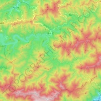
Name: Pinglin District topographic map, elevation, terrain.
Location: Pinglin District, New Taipei, Taiwan (24.83887 121.64465 24.98555 121.79408)
Average elevation: 494 m
Minimum elevation: 11 m
Maximum elevation: 1,098 m
Other topographic maps
Click on a map to view its topography, its elevation and its terrain.
Special-use Zone of National Taipei University
Special-use Zone of National Taipei University, New Taipei, 23854, Taiwan
Average elevation: 50 m
Xinchun Village
Xinchun Village, Tamsui District, New Taipei, Taiwan
Average elevation: 35 m
Teapot Mountain
Teapot Mountain, New Taipei, 22448, Taiwan
Average elevation: 368 m