
Make a donation
Fürstenberg topographic map
Click on the map to display elevation.
Make a donation
About this map
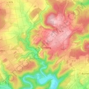
Name: Fürstenberg topographic map, elevation, terrain.
Average elevation: 396 m
Minimum elevation: 267 m
Maximum elevation: 493 m
Make a donation
Other topographic maps
Click on a map to view its topography, its elevation and its terrain.
Allendorf (Eder)
Deutschland > Hessen > Landkreis Waldeck-Frankenberg > Allendorf > Allendorf (Eder)
Average elevation: 360 m
Frankenberg (Eder)
Deutschland > Hessen > Landkreis Waldeck-Frankenberg > Frankenberg > Frankenberg (Eder)
Average elevation: 331 m
Make a donation
Sackpfeife
Deutschland > Hessen > Landkreis Waldeck-Frankenberg > Hatzfeld
Obwohl die Sackpfeife nicht zu den höchsten Bergen des bis zu 843,2 m hohen Rothaargebirges gehört, überragt sie ihre unmittelbare Umgebung doch deutlich bei einer Dominanz von immerhin etwa 8 km. Da der Gipfelbereich in Gebirgsrichtung (Nordnordosten) extrem breit ist, kommt es, dass zwar der höchste…
Average elevation: 558 m
Twistesee
Deutschland > Hessen > Landkreis Waldeck-Frankenberg > Wetterburg > Braunsen
Bereits in den 1920er Jahren gab es erste Überlegungen zum Bau eines Stausees im Twistetal, die aber wegen technischer Probleme verworfen wurden. Das Projekt bekam Aktualität durch das verheerende Hochwasser der Heinrichsflut vom 16./17. Juli 1965, die im Einzugsgebiet von Twiste und Diemel schwere Schäden…
Average elevation: 255 m
Make a donation
Kirchröder Straße
Deutschland > Hessen > Landkreis Waldeck-Frankenberg > Bad Wildungen
Average elevation: 318 m
Unter den Tannen
Deutschland > Hessen > Landkreis Waldeck-Frankenberg > Rhena
Average elevation: 468 m
Rothaargebirge
Deutschland > Hessen > Landkreis Waldeck-Frankenberg > Willingen
Average elevation: 727 m
Meineringhausen
Deutschland > Hessen > Landkreis Waldeck-Frankenberg > Korbach > Meineringhausen
Average elevation: 347 m
Make a donation
Dachsloch
Deutschland > Hessen > Landkreis Waldeck-Frankenberg > Bromskirchen > Dachsloch
Average elevation: 567 m
Reddighausen
Deutschland > Hessen > Landkreis Waldeck-Frankenberg > Hatzfeld > Reddighausen
Average elevation: 392 m
Make a donation
Make a donation
Bromskirchen
Deutschland > Hessen > Landkreis Waldeck-Frankenberg
Der Flecken Fromoldeskirchen mit verstümmelter Martins-Basilika, 1238 Vorort einer Battenberger Kleinzent, war ursprünglich wohl eine karolingische Höhenwegs-Siedlung von Königsleuten. Im Jahre 1238 wurde die Gemeinde erstmals in einer Note des Erzbistums Mainz urkundlich erwähnt. Historisch dokumentierte…
Average elevation: 450 m
Hoher Eimberg
Deutschland > Hessen > Landkreis Waldeck-Frankenberg > Schwalefeld
Average elevation: 644 m
Make a donation
Elisabether Platz
Deutschland > Hessen > Landkreis Waldeck-Frankenberg > Gellershausen
Average elevation: 475 m
Make a donation
Wiesengrund
Deutschland > Hessen > Landkreis Waldeck-Frankenberg > Bömighausen
Average elevation: 508 m
Dietrichshagen
Deutschland > Hessen > Landkreis Waldeck-Frankenberg > Hüddingen
Average elevation: 427 m
Make a donation
Stryck
Deutschland > Hessen > Landkreis Waldeck-Frankenberg > Willingen
Stryck befindet sich knapp zwei Kilometer (Luftlinie) südsüdöstlich vom Willinger Ortskern im Tal der Itter (südwestlicher Zufluss der Diemel) auf Höhen zwischen 590 und 630 m ü. NHN. Die Berge der Dorfumgebung sind alle über 700 m hoch; der höchste Berg ist der westlich gelegene Ettelsberg (837,7 m),…
Average elevation: 675 m
Make a donation
Eilhausen
Deutschland > Hessen > Landkreis Waldeck-Frankenberg > Bad Arolsen > Eilhausen
Average elevation: 318 m
Make a donation
Make a donation
Make a donation
Rothaargebirge
Deutschland > Hessen > Landkreis Waldeck-Frankenberg > Willingen
Average elevation: 727 m
Make a donation