
Make a donation
Kampa County topographic map
Click on the map to display elevation.
Make a donation
About this map
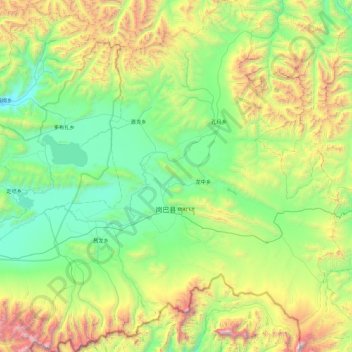
Name: Kampa County topographic map, elevation, terrain.
Location: Kampa County, Shigatse Prefecture, Tibet, 857700, China (27.94067 88.16259 28.75630 88.94661)
Average elevation: 4,993 m
Minimum elevation: 4,256 m
Maximum elevation: 7,067 m
Make a donation
Other topographic maps
Click on a map to view its topography, its elevation and its terrain.
Mount Everest
China > Tibet > Tingri County
Mount Everest (Nepali: सगरमाथा, romanized: Sagarmāthā; Tibetan: Chomolungma ཇོ་མོ་གླང་མ; Chinese: 珠穆朗玛峰; pinyin: Zhūmùlǎngmǎ Fēng) is Earth's highest mountain above sea level, located in the Mahalangur Himal sub-range of the Himalayas. The China–Nepal…
Average elevation: 7,851 m
Make a donation
Lhoka
China > Tibet > Tsetang Township
Shannan has 1 district and 11 counties and its capital is Tsetang, which is located 183 kilometres from Lhasa. It covers an area of 79,700 square kilometres (30,800 sq mi), which includes part of South Tibet, a disputed territory currently under control of the Indian state of Arunachal Pradesh. Its topography…
Average elevation: 4,148 m
Nagqu
Nagqu is located in the northeast of Tibet. Nagqu Town is 330 kilometres (210 mi) by the China National Highway 109 northeast of Lhasa. Nagqu is bordered by Bayingolin and Hotan Prefectures of Xinjiang to the north, Haixi, Yushu Prefectures of Qinghai and Chamdo to the east, Nyingchi, Lhasa and Shigatse to the…
Average elevation: 4,624 m
Lhamo Latso
China > Tibet > Gyatsa County > Cuijiu
Lhamo Latso... [is] a brilliant azure jewel set in a ring of grey mountains. The elevation and the surrounding peaks combine to give it a highly changeable climate, and the continuous passage of cloud and wind creates a constantly moving pattern on the surface of the waters. On that surface visions appear to…
Average elevation: 5,104 m