
Pedrógão Grande topographic map
Interactive map
Click on the map to display elevation.
About this map
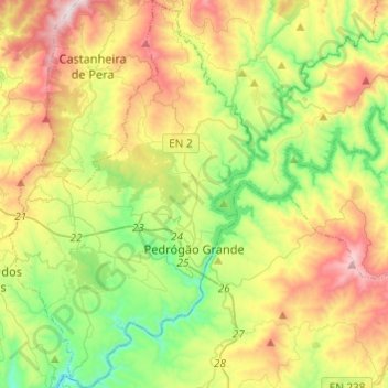
Name: Pedrógão Grande topographic map, elevation, terrain.
Location: Pedrógão Grande, Leiria, Portugal (39.85026 -8.26140 40.03646 -8.10804)
Average elevation: 447 m
Minimum elevation: 124 m
Maximum elevation: 956 m
Other topographic maps
Click on a map to view its topography, its elevation and its terrain.
Casal Novo
Casal Novo, Batalha, Leiria, 2440-117, Portugal
Average elevation: 133 m
Mata Mourisca
Mata Mourisca, Pombal, Leiria, Portugal
Average elevation: 94 m
Arega
Portugal > Leiria > Figueiró dos Vinhos
Arega, Figueiró dos Vinhos, Leiria, Portugal
Average elevation: 270 m
Lagoa
Portugal > Leiria > Chão de Couce > Lagoa
Lagoa, Chão de Couce, Ansião, Leiria, 3240-154, Portugal
Average elevation: 293 m
Alvados e Alcaria
Portugal > Leiria > Alvados e Alcaria
Alvados e Alcaria, Porto de Mós, Leiria, Portugal
Average elevation: 392 m
Murtal
Portugal > Leiria > Pousaflores > Murtal
Murtal, Pousaflores, Ansião, Leiria, 3250-021, Portugal
Average elevation: 241 m