Geolocate

Munster topographic map

Interactive map

Click on the map to display elevation.

About this map

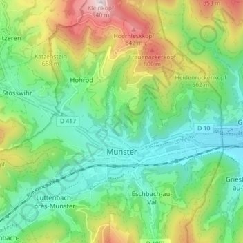
Name: Munster topographic map, elevation, terrain.

Location: Munster, Colmar-Ribeauvillé, Haut-Rhin, Grand Est, France métropolitaine, 68140, France (48.02860 7.09644 48.06463 7.16658)

Average elevation: 529 m

Minimum elevation: 339 m

Maximum elevation: 920 m

La commune est traversée de part et d'autre par deux principaux axes, la D10 venant de Metzeral mais aussi la D417 (anciennement N417) venant de Colmar qui franchit le col de la Schlucht à une altitude de 1139m.

Wikipedia (CC-BY-SA 3.0)

Other topographic maps

Click on a map to view its topography, its elevation and its terrain.

Jebsheim

France > Grand Est > Haut-Rhin

Jebsheim, Colmar-Ribeauvillé, Haut-Rhin, Grand Est, France métropolitaine, 68320, France

Average elevation: 182 m

Steinbach

France > Grand Est > Haut-Rhin

Steinbach, Thann-Guebwiller, Haut-Rhin, Grand Est, France métropolitaine, 68700, France

Average elevation: 441 m

Folgensbourg

France > Grand Est > Haut-Rhin > Folgensbourg

Folgensbourg, Mulhouse, Haut-Rhin, Grand Est, France métropolitaine, 68220, France

Average elevation: 439 m

Mittlach

France > Grand Est > Haut-Rhin

Mittlach, Colmar-Ribeauvillé, Haut-Rhin, Grand Est, France métropolitaine, 68380, France

Average elevation: 862 m

Stosswihr

France > Grand Est > Haut-Rhin

Stosswihr, Colmar-Ribeauvillé, Haut-Rhin, Grand Est, France métropolitaine, 68140, France

Average elevation: 708 m

Kembs

France > Grand Est > Haut-Rhin

Kembs, Mulhouse, Haut-Rhin, Grand Est, France métropolitaine, 68680, France

Average elevation: 263 m

Guémar

France > Grand Est > Haut-Rhin > Guémar

Guémar, Colmar-Ribeauvillé, Haut-Rhin, Grand Est, France métropolitaine, 68970, France

Average elevation: 190 m