
Port Sudan topographic map
Interactive map
Click on the map to display elevation.
About this map
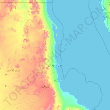
Name: Port Sudan topographic map, elevation, terrain.
Location: Port Sudan, Red Sea State, 79800, Sudan (19.00979 33.25248 21.12145 37.55506)
Average elevation: 292 m
Minimum elevation: -3 m
Maximum elevation: 2,127 m
Other topographic maps
Click on a map to view its topography, its elevation and its terrain.
Jibal Matalya
Sudan > Red Sea State > Port Sudan
Jibal Matalya, Port Sudan, Red Sea State, Sudan
Average elevation: 310 m
Quarantine Island
Sudan > Red Sea State > Port Sudan
Quarantine Island, Port Sudan, Red Sea State, Sudan
Average elevation: 98 m
Jabal Atit Arut
Sudan > Red Sea State > Port Sudan
Jabal Atit Arut, Port Sudan, Red Sea State, Sudan
Average elevation: 735 m