
Quarantine Island topographic map
Interactive map
Click on the map to display elevation.
About this map
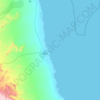
Name: Quarantine Island topographic map, elevation, terrain.
Location: Quarantine Island, Port Sudan, Red Sea State, Sudan (18.80167 37.04972 19.44167 37.68972)
Average elevation: 98 m
Minimum elevation: -3 m
Maximum elevation: 1,173 m
Other topographic maps
Click on a map to view its topography, its elevation and its terrain.
Jibal Matalya
Sudan > Red Sea State > Port Sudan
Jibal Matalya, Port Sudan, Red Sea State, Sudan
Average elevation: 310 m
Jabal Atit Arut
Sudan > Red Sea State > Port Sudan
Jabal Atit Arut, Port Sudan, Red Sea State, Sudan
Average elevation: 735 m