
Nabasan Bay topographic map
Interactive map
Click on the map to display elevation.
About this map
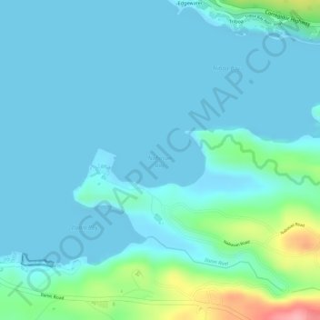
Name: Nabasan Bay topographic map, elevation, terrain.
Location: Nabasan Bay, Bataan, Central Luzon, Philippines (14.77086 120.25939 14.77553 120.26773)
Average elevation: 20 m
Minimum elevation: 0 m
Maximum elevation: 126 m
Other topographic maps
Click on a map to view its topography, its elevation and its terrain.
Tugatog
Philippines > Bataan > Orani
Tugatog, Orani, Bataan, Central Luzon, 2122, Philippines
Average elevation: 13 m
Grande Island
Grande Island, Bataan, Central Luzon, Philippines
Average elevation: 1 m
Orion
Philippines > Bataan > Orion
Orion, Bataan, Central Luzon, 2102, Philippines
Average elevation: 21 m
Balanga
Philippines > Bataan > Balanga
Balanga, Bataan, Central Luzon, 2100, Philippines
Average elevation: 134 m